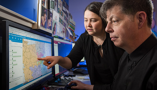
Tricia Foster and Charles Summerhill are the most delightful people providing the most helpful data. They are the geographic mapping experts at Texas Children’s Health Plan.
When you step into their office you feel invited, intrigued and ultimately in awe of the work they do each day to care for our members.
So what exactly do they do?
To the untrained eye the world of GeoMapping seems complicated, but essentially Foster and Summerhill – along with the Business Intelligence Analytics team – build and analyze maps. These maps are then used to meet member, clinical, financial, and operational business needs.
“We use technology that allows us to see where our members are, the resources that are nearby and how to get those resources to them as quickly as possible,” said Foster, senior business intel analyst. “Many times when you work with data and technology you aren’t really sure how your work translates to patient care, but in this job we know we are making a big difference.”
How big?
Big is probably not a big enough word. In recent years the team has had a chance to help patients in the aftermath of some major situations like Hurricane Harvey and the plant explosion in Crosby, Texas.
“On day one of the Crosby explosion we were able to tell the Care Coordination team which members were within a one mile radius of the event and which ones had asthma or breathing related health issues,” said Summerhill, senior business intel analyst.
Foster chimed in with an obvious question – “How many times do you get a call from your insurance company asking how they can help you? People just don’t expect it and it’s wonderful when we can go in and be helpful in times like that.”
The Health Plan’s Mission Control project is another example of how their work has been used to help meet organizational goals.
What can the maps tell us?
The capabilities for the map data are unlimited and always evolving. In addition to knowing where our members are located, we can also tell them the locations of nearby:
- Provider offices (Doctors, Therapists, etc.)
- Emergency rooms and Urgent Care Clinics
- Transportation services (bus stops, rail stops, etc.)
- Pharmacies
- Labs
But wait, there’s more.
The GeoMapping technology also helps prove that we are meeting state requirements such as having enough providers within a certain proximity to our members. Texas Health and Human Services Commission – the state agency that funds The Health Plan – wants to know that we are making care convenient for our families.
“In addition we can tell if our members are in a food desert,” Summerhill said. “If access to healthy and nutritious food is tough for the family, that is something our member service and care coordination teams should know. There are a variety of factors that impact member care.”
Want to know more about GeoMapping at The Health Plan? Contact Kim Battenfield, manager of Clinical and Business Analytics at kabatten@texaschildrens.org.
What You Need to Know
GeoMapping – When clinical and business data is used to build a map.
Members – Children and women who have insurance through Texas Children’s Health Plan. While Texas Children’s Hospital has patients, Texas Children’s Health Plan has members.
Member Services – The department at Texas Children’s Health Plan that speaks one on one with members to answer questions and provide assistance. You’ll often hear this group referred to as “the call center staff.” Our member services representatives work in our call center on the 10th floor of the 6330 West Loop South building in Bellaire.
Care Coordination – Staff who work directly with families to ensure that their care is managed. Care coordinators work in a case manager or social worker capacity. A great deal of care coordinator work remotely and are often called the “road warriors.”
Food Desert – an urban area in which it is difficult to buy affordable or good-quality fresh food.